Description of the geocoding process

Data cleansing
All redundant notes and comments are deleted and merged together.

Field mapping
All data are transcribed based on their value (e.g. building number separate from the street name).

Search
Check without aliases and basic address database. In case of inaccurate results – extending the search to a larger area, approximate names of settlements.

Results evaluation
Each record is evaluated for matching fields and the estimated radius of potential error.

Results sorting
The results are returned in the order depending on their quality, the size of the place and even the popularity of searches for a given query.
Możliwość integracji
Przekazanie plików CSV/ Excel
- Kodowanie UTF-8
- W przypadku pliku CSV kolumny powinny być rozdzielone średnikiem oraz zawartość pól tekstowych powinna być ujęta w cudzysłów
- Obsługiwane kolumny (mapowane automatycznie) województwo, powiat, gmina, miejscowość, kod pocztowy, ulica, numer budynku (może być podany w kolumnie ulica)
- Plik będzie wzbogacony o dodatkowe kolumny z wynikiem geokodowania każdego rekordu
- Dodatkowo zostanie dostarczona statystyka rozkładu jakości geokodowania
API webservice
- API dostępne w protokole REST lub SOAP
- Wymiana danych poprzez format UTF-8 JSON
- Dostępne metody do pojedynczego odpytywania oraz do wysyłania paczek zapytań (tzw. bulk request)
Inne
- Połączenie z bazą danych
- Panel online
- Metody dedykowane
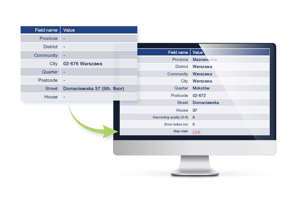
Rekord
adresowy
Standardowy zgeokodowany rekord będzie zawierał pełną strukturę administracyjną (województwo, powiat, gmina), miejscowość, dzielnicę, kod pocztowy, ulicę, numer budynku, kod TERYT (do poziomu ulicy), indeks jakości geokodowania (0-9), promień potencjalnego błędu geodkowowania (w metrach) oraz link umożliwiający podgląd adresu na mapie Targeo.
Geocoding
extended – packages
- Type of building (residential, commercial, mixed)
- Number of households
- Number of inhabitants (broken down by W/M)
- POI counting in X meter radius (up to 5 POI categories) e.g. number of ATMs in a 500-meter radius
- Determining the distance to the nearest POI from a selected category (up to 5 categories), e.g. the nearest pharmacy
- Traffic volume index for defined time slots (e.g. the morning in work days)
- Purchase Power including per capita
- Expenditure broken down into a dozen or so categories
- Unemployment rate